 VoGIS Metadatenkatalog
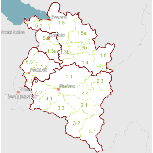
Rotwildregionen Vorarlberg - wildökologische Raumplanung
Unterteilung der Rotwildräume in Rotwildregionen
Wichtige Felder und Datentypen der Attributtabelle (jene, die inhaltliche Informationen enthalten):
nummer (string)
name (string)
Datenquelle: wildregion.shp
Simple
- Date (Creation)
- 2009-12-14T11:30:00
- Date (Revision)
- 2025-06-16T03:42:54
- Identifier
- eb73ceb8-c9e7-4a40-a83c-e448eb126a5f
- Presentation form
- Digital map
- Status
- On going
+43 (0) 5574 / 511-925195
https://vorarlberg.at/-/abteilung-landwirtschaft-und-laendlicher-raum
+43 (0) 5574 / 511-925195
https://vorarlberg.at/-/abteilung-landwirtschaft-und-laendlicher-raum
+43 (0) 5522 / 754826
https://vorarlberg.at/-/landesamt-fuer-vermessung-und-geoinformation-l-1?article_id=122572
+43 (0) 5574 / 511-925195
https://vorarlberg.at/-/abteilung-landwirtschaft-und-laendlicher-raum
- Maintenance and update frequency
- As needed
-
VOGIS Thema 1.0.0
-
-
landwirtschaft
-
-
VOGIS Unterthema 1.0.0
-
-
jagd
-
- Theme
-
-
wildregionen, rotwild
-
wildpopulation
-
wild
-
bodenbedeckung
-
wildtier
-
raumplanung
-
- Access constraints
- Other restrictions
- Spatial representation type
- Vector
- Denominator
- 5000
- Metadata language
-
ger
- Character set
- UTF8
- Topic category
-
- Farming
- Begin date
- 2012-02-14T11:39:00
- End date
- 2022-02-14T11:40:00
))
- Supplemental Information
-
Die Standardausdehnung erstreckt sich über das Land Vorarlberg. Andere Bereiche müssen zusätzlich dokumentiert werden.
- Reference system identifier
- EPSG / MGI / Austria GK West (EPSG:31254) / 7.4
- Distribution format
-
-
ESRI Shapefile
(
1.0
)
-
ESRI Shapefile
(
1.0
)
- OnLine resource
- Info ( WWW:LINK-1.0-http--link )
- OnLine resource
- Geoserver-WMS ( OGC:WMS-http-get-capabilities )
- OnLine resource
- Geoserver-WFS ( OGC:WFS-http-get-capabilities )
- OnLine resource
-
Shapefile-Download
(
WWW:DOWNLOAD-1.0-http--download
)
Achtung !! max. Features = 100.000
- OnLine resource
-
Geopackage-Download
(
WWW:DOWNLOAD-1.0-http--download
)
Achtung !! max. Features = 100.000
- File identifier
- eb73ceb8-c9e7-4a40-a83c-e448eb126a5f XML
- Metadata language
-
ger
- Character set
- UTF8
- Hierarchy level
- Dataset
- Date stamp
- 2025-06-16T03:42:54
- Metadata standard name
-
ISO 19115:2003/19139
- Metadata standard version
-
1.0
+43 (0) 5522 / 754826
https://vorarlberg.at/-/landesamt-fuer-vermessung-und-geoinformation-l-1?article_id=122572
Overviews
Spatial extent
Provided by
