 VoGIS Metadatenkatalog
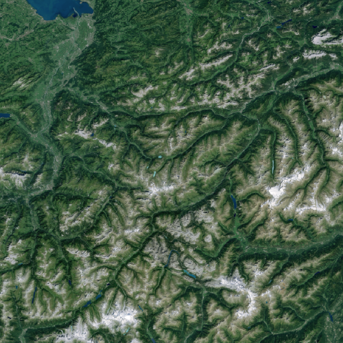
Sentinel Satellitenbild Mosaik Vorarlberg und Umgebung 2020 (Fremddaten)
Sentinel-2 RGB-Mosaik von Vorarlberg plus der Umgebung von Vorarlberg, 3-Kanal 8 Bit RGB Tif, 10m Auflösung
Datenquelle:
Sentinel NPOC Schweiz ( https://www.npoc.ch/en/services/products.html), "Contains modified Copernicus Sentinel data 2020 swisstopo, NPOC"
Daten sind Fremddaten aber OGD und dürfen geteilt werden (Auch freier Download).
Simple
- Date (Creation)
- 2020-01-01
- Date (Revision)
- 2020-02-01T12:00:00
- Unique resource identifier
- d98b61bc-18a5-4dac-a18e-16fdc42231a1
- Status
- Completed
Point of contact
Vorarlberg, Landesamt für Vermessung und Geoinformation, Abteilung Geoinformation
+43 (0) 5522 / 754826
https://vorarlberg.at/-/landesamt-fuer-vermessung-und-geoinformation-l-1?article_id=122572
Johannitergasse 6
,
Feldkirch
,
6800
,
Austria
+43 (0) 5522 / 75482
+43 (0) 5522 / 754826
https://vorarlberg.at/-/landesamt-fuer-vermessung-und-geoinformation-l-1?article_id=122572
Custodian
Vorarlberg, Landesamt für Vermessung und Geoinformation, Abteilung Geoinformation
+43 (0) 5522 / 754826
https://vorarlberg.at/-/landesamt-fuer-vermessung-und-geoinformation-l-1?article_id=122572
Johannitergasse 6
,
Feldkirch
,
6800
,
Austria
+43 (0) 5522 / 75482
+43 (0) 5522 / 754826
https://vorarlberg.at/-/landesamt-fuer-vermessung-und-geoinformation-l-1?article_id=122572
Publisher
Vorarlberg, Landesamt für Vermessung und Geoinformation, Abteilung Geoinformation
+43 (0) 5522 / 754826
https://vorarlberg.at/-/landesamt-fuer-vermessung-und-geoinformation-l-1?article_id=122572
Johannitergasse 6
,
Feldkirch
,
6800
,
Austria
+43 (0) 5522 / 75482
+43 (0) 5522 / 754826
https://vorarlberg.at/-/landesamt-fuer-vermessung-und-geoinformation-l-1?article_id=122572
Owner
Swisstopo Bundesamt für Landestopografie
-
+41 58 469 04 59
http://www.swisstopo.admin.ch/
Seftigenstrasse 264
,
Wabern
,
3084
,
Schweiz
+41 58 469 01 11
+41 58 469 04 59
http://www.swisstopo.admin.ch/
- Maintenance and update frequency
- Not planned
-
VOGIS Thema 1.0.0
-
-
luftbilder
-
-
VOGIS Unterthema 1.0.0
-
-
satellitenbilder
-
-
GEMET - INSPIRE themes, version 1.0
-
-
orthofotografie
-
-
GEMET
-
-
satellitenbild
-
- Use limitation
- Access constraints
- Copyright
- Use constraints
- otherRestictions
- Spatial representation type
- Grid
Spatial resolution
- Distance
- 10 m
- Metadata language
-
ger
- Character set
- UTF8
- Topic category
-
- Planning cadastre
N
S
E
W
))
- Supplemental Information
-
Vorarlberg plus der Umgebung von Vorarlberg
- Reference system identifier
- EPSG / MGI / Austria GK West (EPSG:31254) / 8.6
- Distribution format
-
-
TIFF
(
)
-
TIFF
(
)
- Hierarchy level
- Dataset
- Statement
-
NPOC National Point of Contact swisstopo
- File identifier
- d98b61bc-18a5-4dac-a18e-16fdc42231a1 XML
- Metadata language
- Deutsch
- Character set
- UTF8
- Hierarchy level
- Dataset
- Date stamp
- 2025-04-14T14:59:58
- Metadata standard name
-
ISO 19115:2003/19139
- Metadata standard version
-
1.0
Point of contact
Vorarlberg, Landesamt für Vermessung und Geoinformation, Abteilung Geoinformation
+43 (0) 5522 / 754826
https://vorarlberg.at/-/landesamt-fuer-vermessung-und-geoinformation-l-1?article_id=122572
Johannitergasse 6
,
Feldkirch
,
6800
,
Austria
+43 (0) 5522 / 75482
+43 (0) 5522 / 754826
https://vorarlberg.at/-/landesamt-fuer-vermessung-und-geoinformation-l-1?article_id=122572
Overviews
Spatial extent
N
S
E
W
Provided by

Associated resources
Not available