 VoGIS Metadatenkatalog
Flugübersichten Schrägluftbildbefliegung Vorarlberg 2018
Flugübersichten (Flugpfade, Auslösepunkte) Schrägluftbildbefliegungen Raumplanung 2018
Wichtige Felder und Datentypen der Attributtabelle:
Datenquelle: schraegluftbilder_flugpfad_2018.shp
Simple
- Date (Creation)
- 2017-09-14
- Date (Revision)
- 2018-03-03
- Identifier
- AT.0025.31.00 / 2ddd5ddd-4fe9-45c2-864b-5d800f7ad18c
- Presentation form
- Digital map
- Status
- Historical archive
Point of contact
Vorarlberg, Landesamt für Vermessung und Geoinformation, Abteilung Geoinformation
+43 (0) 5522 / 754826
https://vorarlberg.at/-/landesamt-fuer-vermessung-und-geoinformation-l-1?article_id=122572
Johannitergasse 6
,
Feldkirch
,
6800
,
Austria
+43 (0) 5522 / 75482
+43 (0) 5522 / 754826
https://vorarlberg.at/-/landesamt-fuer-vermessung-und-geoinformation-l-1?article_id=122572
Custodian
Vorarlberg, Landesamt für Vermessung und Geoinformation, Abteilung Geoinformation
+43 (0) 5522 / 754826
https://vorarlberg.at/-/landesamt-fuer-vermessung-und-geoinformation-l-1?article_id=122572
Johannitergasse 6
,
Feldkirch
,
6800
,
Austria
+43 (0) 5522 / 75482
+43 (0) 5522 / 754826
https://vorarlberg.at/-/landesamt-fuer-vermessung-und-geoinformation-l-1?article_id=122572
Publisher
Vorarlberg, Landesamt für Vermessung und Geoinformation, Abteilung Geoinformation
+43 (0) 5522 / 754826
https://vorarlberg.at/-/landesamt-fuer-vermessung-und-geoinformation-l-1?article_id=122572
Johannitergasse 6
,
Feldkirch
,
6800
,
Austria
+43 (0) 5522 / 75482
+43 (0) 5522 / 754826
https://vorarlberg.at/-/landesamt-fuer-vermessung-und-geoinformation-l-1?article_id=122572
Owner
Vorarlberg, Landesamt für Vermessung und Geoinformation, Abteilung Geoinformation
+43 (0) 5522 / 754826
https://vorarlberg.at/-/landesamt-fuer-vermessung-und-geoinformation-l-1?article_id=122572
Johannitergasse 6
,
Feldkirch
,
6800
,
Austria
+43 (0) 5522 / 75482
+43 (0) 5522 / 754826
https://vorarlberg.at/-/landesamt-fuer-vermessung-und-geoinformation-l-1?article_id=122572
-
VOGIS Thema 1.0.0
-
-
luftbilder
-
-
VOGIS Unterthema 1.0.0
-
-
schraegluftbilder
-
- Keywords
-
-
schrägluftbild
-
flugpfad
-
-
GEMET
-
-
luftbild
-
- Access constraints
- Copyright
- Spatial representation type
- Vector
- Denominator
- 5000
- Metadata language
- Deutsch
- Topic category
-
- Planning cadastre
N
S
E
W
))
- Reference system identifier
- EPSG / MGI / Austria GK West (EPSG:31254) / 7.9
- Distribution format
-
-
ESRI Shapefile
(
1.0
)
-
ESRI Shapefile
(
1.0
)
- File identifier
- 2ddd5ddd-4fe9-45c2-864b-5d800f7ad18c XML
- Metadata language
- Deutsch
- Hierarchy level
- Dataset
- Date stamp
- 2025-04-14T14:58:40
- Metadata standard name
-
ISO19115
- Metadata standard version
-
2003/Cor.1:2006
Overviews
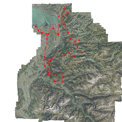
Schrägluftbild Flugpfad 2018
Spatial extent
N
S
E
W
Provided by

Associated resources
Not available