 VoGIS Metadatenkatalog
Historische Gewässerkarte von Vorarlberg 1:100.000, ohne Jahr (Fremddaten)
Historische Gewässerkarte von Vorarlberg 1:100.000, ohne Jahr, 5m Auflösung
1 Kanal 8Bit Tif (Palette)
Datenquelle:
gewaesserkarte_gk_5m.tif
Simple
- Date (Creation)
- 2009-12-09
- Date (Revision)
- 2019-07-08T12:00:00
- Unique resource identifier
- 612198df-591f-40ec-994d-0a7c5251fc49
Owner
Bundesamt für Eich- und Vermessungswesen
-
+43 1 21110-992161
https://www.bev.gv.at/public.html
Obere Donaustraße 55
,
Wien
,
1020
,
Austria
+43 1 21110-2160
+43 1 21110-992161
https://www.bev.gv.at/public.html
Point of contact
Vorarlberg, Landesamt für Vermessung und Geoinformation, Abteilung Geoinformation
+43 (0) 5522 / 754826
https://vorarlberg.at/-/landesamt-fuer-vermessung-und-geoinformation-l-1?article_id=122572
Johannitergasse 6
,
Feldkirch
,
6800
,
Austria
+43 (0) 5522 / 75482
+43 (0) 5522 / 754826
https://vorarlberg.at/-/landesamt-fuer-vermessung-und-geoinformation-l-1?article_id=122572
Publisher
Vorarlberg, Landesamt für Vermessung und Geoinformation, Abteilung Geoinformation
+43 (0) 5522 / 754826
https://vorarlberg.at/-/landesamt-fuer-vermessung-und-geoinformation-l-1?article_id=122572
Johannitergasse 6
,
Feldkirch
,
6800
,
Austria
+43 (0) 5522 / 75482
+43 (0) 5522 / 754826
https://vorarlberg.at/-/landesamt-fuer-vermessung-und-geoinformation-l-1?article_id=122572
Custodian
Vorarlberg, Landesamt für Vermessung und Geoinformation, Abteilung Geoinformation
+43 (0) 5522 / 754826
https://vorarlberg.at/-/landesamt-fuer-vermessung-und-geoinformation-l-1?article_id=122572
Johannitergasse 6
,
Feldkirch
,
6800
,
Austria
+43 (0) 5522 / 75482
+43 (0) 5522 / 754826
https://vorarlberg.at/-/landesamt-fuer-vermessung-und-geoinformation-l-1?article_id=122572
- Maintenance and update frequency
- Not planned
-
VOGIS Thema 1.0.0
-
-
topographische_karten
-
-
VOGIS Unterthema 1.0.0
-
-
historische_karten
-
-
GEMET - INSPIRE themes, version 1.0
-
-
gewässernetz
-
-
GEMET
-
-
gewässer
-
- Keywords
-
-
historisch
-
- Access constraints
- Copyright
- Use constraints
- otherRestictions
- Spatial representation type
- Grid
Spatial resolution
- Distance
- 5 m
- Metadata language
-
ger
- Character set
- UTF8
- Topic category
-
- Inland waters
N
S
E
W
))
- Reference system identifier
- EPSG / MGI / Austria GK West (EPSG:31254) / 8.6
- Distribution format
-
-
ECW
(
)
-
ECW
(
)
- OnLine resource
- gewaesserkarte_gk_5m ( OGC:WMS-http-get-capabilities )
- Hierarchy level
- Dataset
- Statement
-
Eigene Erstellung
- File identifier
- 612198df-591f-40ec-994d-0a7c5251fc49 XML
- Metadata language
- Deutsch
- Character set
- UTF8
- Hierarchy level
- Dataset
- Date stamp
- 2025-04-14T14:58:58
- Metadata standard name
-
ISO 19115:2003/19139
- Metadata standard version
-
1.0
Point of contact
Vorarlberg, Landesamt für Vermessung und Geoinformation, Abteilung Geoinformation
+43 (0) 5522 / 754826
https://vorarlberg.at/-/landesamt-fuer-vermessung-und-geoinformation-l-1?article_id=122572
Johannitergasse 6
,
Feldkirch
,
6800
,
Austria
+43 (0) 5522 / 75482
+43 (0) 5522 / 754826
https://vorarlberg.at/-/landesamt-fuer-vermessung-und-geoinformation-l-1?article_id=122572
Overviews
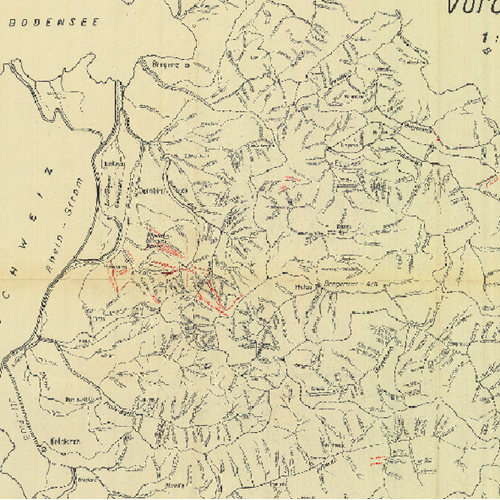
Historische Gewässerkarte
Spatial extent
N
S
E
W
Provided by

Associated resources
Not available