 VoGIS Metadatenkatalog
Neigung des Geländemodells Vorarlberg 2002-04 in Prozent, 5m Auflösung
Neigung des Geländemodells Vorarlberg 2002-04 (1. Laserscanning-Aufnahme) in Prozent, 5m
1 Kanal 16 Bit Signed-Integer Erdas Imagine Höhenmodell
Datenquelle:
st2004_05m_pz.img
Simple
- Date (Creation)
- 2015-06-18
- Date (Revision)
- 2019-07-08T12:00:00
- Unique resource identifier
- 5fcc14c7-adce-4273-a52c-f4be04ea070c
Point of contact
Vorarlberg, Landesamt für Vermessung und Geoinformation, Abteilung Geoinformation
+43 (0) 5522 / 754826
https://vorarlberg.at/-/landesamt-fuer-vermessung-und-geoinformation-l-1?article_id=122572
Johannitergasse 6
,
Feldkirch
,
6800
,
Austria
+43 (0) 5522 / 75482
+43 (0) 5522 / 754826
https://vorarlberg.at/-/landesamt-fuer-vermessung-und-geoinformation-l-1?article_id=122572
Custodian
Vorarlberg, Landesamt für Vermessung und Geoinformation, Abteilung Geoinformation
+43 (0) 5522 / 754826
https://vorarlberg.at/-/landesamt-fuer-vermessung-und-geoinformation-l-1?article_id=122572
Johannitergasse 6
,
Feldkirch
,
6800
,
Austria
+43 (0) 5522 / 75482
+43 (0) 5522 / 754826
https://vorarlberg.at/-/landesamt-fuer-vermessung-und-geoinformation-l-1?article_id=122572
Publisher
Vorarlberg, Landesamt für Vermessung und Geoinformation, Abteilung Geoinformation
+43 (0) 5522 / 754826
https://vorarlberg.at/-/landesamt-fuer-vermessung-und-geoinformation-l-1?article_id=122572
Johannitergasse 6
,
Feldkirch
,
6800
,
Austria
+43 (0) 5522 / 75482
+43 (0) 5522 / 754826
https://vorarlberg.at/-/landesamt-fuer-vermessung-und-geoinformation-l-1?article_id=122572
Owner
Vorarlberg, Landesamt für Vermessung und Geoinformation, Abteilung Geoinformation
+43 (0) 5522 / 754826
https://vorarlberg.at/-/landesamt-fuer-vermessung-und-geoinformation-l-1?article_id=122572
Johannitergasse 6
,
Feldkirch
,
6800
,
Austria
+43 (0) 5522 / 75482
+43 (0) 5522 / 754826
https://vorarlberg.at/-/landesamt-fuer-vermessung-und-geoinformation-l-1?article_id=122572
- Maintenance and update frequency
- Not planned
-
VOGIS-Thema
-
-
Gelaendemodelle
-
-
VOGIS-Unterthema
-
-
Neigung
-
-
GEMET - INSPIRE themes, version 1.0
-
-
Höhe
-
-
GEMET - Concepts, version 3.1
-
-
Digitales Geländemodell
-
Höhe
-
- Keywords
-
-
Laserscanning
-
Vorarlberg
-
- Access constraints
- Copyright
- Use constraints
- otherRestictions
Resource constraints
No information provided.
- Spatial representation type
- Grid
- Distance
- 5 m
- Metadata language
-
ger
- Character set
- UTF8
- Topic category
-
- Planning cadastre
N
S
E
W
))
- Reference system identifier
- EPSG / MGI / Austria GK West (EPSG:31254) / 8.6
- Distribution format
-
-
IMG
(
-
)
-
IMG
(
-
)
- Statement
-
Eigene Erfassung
- File identifier
- 5fcc14c7-adce-4273-a52c-f4be04ea070c XML
- Metadata language
- Deutsch
- Character set
- UTF8
- Hierarchy level
- Dataset
- Date stamp
- 2023-08-03T13:20:53
- Metadata standard name
-
ISO 19115:2003/19139
- Metadata standard version
-
1.0
Point of contact
Vorarlberg, Landesamt für Vermessung und Geoinformation, Abteilung Geoinformation
+43 (0) 5522 / 754826
https://vorarlberg.at/-/landesamt-fuer-vermessung-und-geoinformation-l-1?article_id=122572
Johannitergasse 6
,
Feldkirch
,
6800
,
Austria
+43 (0) 5522 / 75482
+43 (0) 5522 / 754826
https://vorarlberg.at/-/landesamt-fuer-vermessung-und-geoinformation-l-1?article_id=122572
Overviews
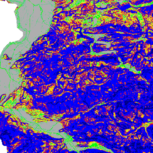
Neigung in Prozent
Spatial extent
N
S
E
W
Provided by

Associated resources
Not available