 VoGIS Metadatenkatalog
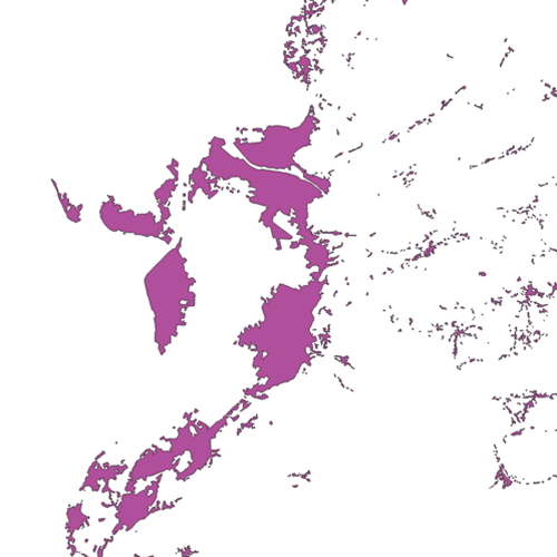
Siedlungsgebiet 2001 Vorarlberg
Siedlungsgebiet 2001 in Vorarlberg. Polygon auf Basis vom Luftbild.
Wichtige Felder und Datentypen der Attributtabelle:
Name, Typ, Feldlänge, Beschreibung
ORTHO_F_JAH, Integer, 4, Erfassungsjahr
Datenquelle: siedlung_orthofoto_2001.shp
Simple
- Date (Creation)
- 2009-11-18
- Date (Revision)
- 2019-07-08T12:00:00
- Identifier
- AT.0025.31.00 / d745d596-577a-4ada-b7cb-284397a76bbd
- Presentation form
- Digital map
+43 (0) 5574 / 511-927195
https://vorarlberg.at/-/raumplanung-und-baurecht
+43 (0) 5574 / 511-927195
https://vorarlberg.at/-/raumplanung-und-baurecht
+43 (0) 5522 / 754826
https://vorarlberg.at/-/landesamt-fuer-vermessung-und-geoinformation-l-1?article_id=122572
- Status
- Completed
+43 (0) 5574 / 511-927195
https://vorarlberg.at/-/raumplanung-und-baurecht
-
VOGIS Thema 1.0.0
-
-
raumplanung
-
-
VOGIS Unterthema 1.0.0
-
-
siedlung
-
- Keywords
-
-
ortsmittelpunkt
-
bebaute fläche
-
bodennutzung
-
-
GEMET - INSPIRE themes, version 1.0
-
-
bodennutzung
-
-
GEMET
-
-
bebaute fläche
-
bauland
-
flächenwidmung
-
- Access constraints
- Other restrictions
- Other constraints
-
no limitations
- Denominator
- 5000
- Metadata language
- Deutsch
- Topic category
-
- Planning cadastre
))
- Reference system identifier
- EPSG / MGI / Austria GK West (EPSG:31254) / 7.9
- Distribution format
-
-
ESRI Shapefile
(
1.0
)
-
ESRI Shapefile
(
1.0
)
- OnLine resource
- Geoserver-WMS ( OGC:WMS-http-get-capabilities )
- OnLine resource
- Geoserver-WFS ( OGC:WFS-http-get-capabilities )
- OnLine resource
-
Shapefile-Download
(
WWW:DOWNLOAD-1.0-http--download
)
Achtung !! max. Features = 100.000
- OnLine resource
-
Geopackage-Download
(
WWW:DOWNLOAD-1.0-http--download
)
Achtung !! max. Features = 100.000
- Hierarchy level
- Dataset
- Statement
-
digitalisiert auf Basis der Orthofotos
- File identifier
- d745d596-577a-4ada-b7cb-284397a76bbd XML
- Metadata language
- Deutsch
- Hierarchy level
- Dataset
- Date stamp
- 2025-04-14T14:42:37
- Metadata standard name
-
ISO19115
- Metadata standard version
-
2003/Cor.1:2006
Overviews
Spatial extent
Provided by
