 VoGIS Metadatenkatalog
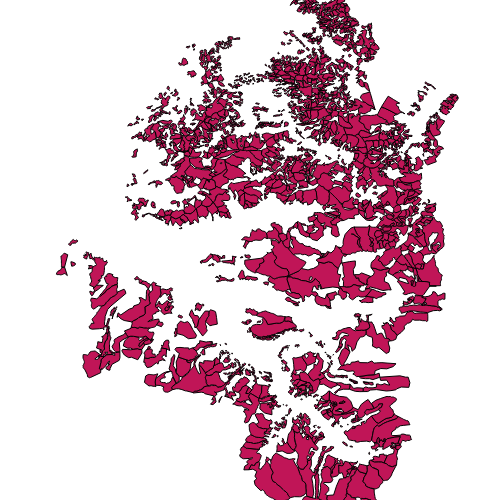
Alpen, Vor- und Maisäße Vorarlberg
Alpflächen, Maisäße und Vorsäße
Grundlage: Urmappe, Grundbuch und Alpdatenbank
Abbildung der Flächen durch Digitalisierung oder durch Zusammenfassen von Grundstücken einzelner Alpflächen.
Ist für INSPIRE gemeldet.
Wichtige Felder und Datentypen der Attributtabelle (jene, die inhaltliche Informationen enthalten):
Alpname (String)
Nutzung (String) Nutzung = (Alpe,Vorsäß,Maisäß)
Datenquelle: Alpen_Vorsaess_Maisaess.shp
Simple
- Date (Creation)
- 2010-01-10
- Date (Revision)
- 2019-07-08T12:00:00
- Identifier
- https://data.inspire.gv.at/0025/81be102a-f5bb-4e36-95e7-84afa238df71
+43 (0) 5574 / 511-925195
https://vorarlberg.at/-/abteilung-landwirtschaft-und-laendlicher-raum
+43 (0) 5574 / 511-925195
https://vorarlberg.at/-/abteilung-landwirtschaft-und-laendlicher-raum
+43 (0) 5522 / 754826
https://vorarlberg.at/-/landesamt-fuer-vermessung-und-geoinformation-l-1?article_id=122572
+43 (0) 5574 / 511-925195
https://vorarlberg.at/-/abteilung-landwirtschaft-und-laendlicher-raum
-
VOGIS Thema 1.0.0
-
-
landwirtschaft
-
-
VOGIS Unterthema 1.0.0
-
-
nutzung
-
-
GEMET - INSPIRE themes, version 1.0
-
-
bewirtschaftungsgebiete/schutzgebiete/geregelte gebiete und berichterstattungseinheiten
-
- Keywords
-
-
alpen
-
-
GEMET
-
-
grünland
-
bewirtschaftungsform
-
nachhaltige bewirtschaftung
-
weide
-
-
Spatial scope
- Access constraints
- Other restrictions
- Use constraints
- Other restrictions
- Other constraints
- Namensnennung 4.0 International (CC BY 4.0)
- Other constraints
-
(c) Land Vorarlberg
- Spatial representation type
- Vector
- Denominator
- 5000
- Metadata language
- Deutsch
- Topic category
-
- Economy
))
- Begin date
- 2013-01-01
- End date
- 2017-03-31
- Reference system identifier
- http://www.opengis.net/def/crs/EPSG/0/31254
- Reference system identifier
- http://www.opengis.net/def/crs/EPSG/0/3035
- Reference system identifier
- http://www.opengis.net/def/crs/EPSG/0/4036
- Distribution format
-
-
ESRI Shapefile
(
-
)
-
ESRI Shapefile
(
-
)
- OnLine resource
- Darstellungsdienst Alpen ( OGC:WMS-http-get-capabilities )
- OnLine resource
-
Vor- und Maisäße Vorarlberg
(
WWW:DOWNLOAD-1.0-http--download
)
Vor- und Maisäße Vorarlberg als atom-feed
- OnLine resource
- Geoserver-WMS ( OGC:WMS-http-get-capabilities )
- OnLine resource
- Geoserver-WFS ( OGC:WFS-http-get-capabilities )
- OnLine resource
-
Shapefile-Download
(
WWW:DOWNLOAD-1.0-http--download
)
Achtung !! max. Features = 100.000
- OnLine resource
-
Geopackage-Download
(
WWW:DOWNLOAD-1.0-http--download
)
Achtung !! max. Features = 100.000
- Hierarchy level
- Dataset
Domain consistency
- Measure identification
- INSPIRE / Conformity_001
Conformance result
- Date (Publication)
- 2010-12-08
- Explanation
-
siehe Referenzdokument (INSPIRE Technical Guidelines)
- Pass
- Yes
- Statement
-
Hersteller: Amt der Landesregierung, Abteilung Vc - Forstwesen
- File identifier
- 81be102a-f5bb-4e36-95e7-84afa238df71 XML
- Metadata language
- Deutsch
- Hierarchy level
- Dataset
- Date stamp
- 2025-04-14T14:44:08
- Metadata standard name
-
ISO19115
- Metadata standard version
-
2003/Cor.1:2006
+43 (0) 5522 / 754826
https://vorarlberg.at/-/landesamt-fuer-vermessung-und-geoinformation-l-1?article_id=122572
Overviews
Spatial extent
Provided by
