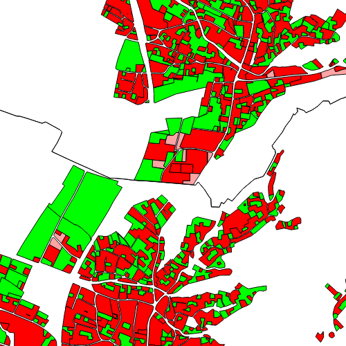
Bauflächenwidmung Vorarlberg
Die Bauflächenwidmung Vorarlbergs zeigt alle Flächen an, die laut Raumplanungsgesetz als Bauflächen (Definition Bauflächen: §13 RPG) gewidmet wurden. Dazu zählen Baufläche-Kerngebiet (BK), Baufläche-Wohngebiet (BW), Baufläche-Mischgebiet (BM) und Baufläche-Betriebsgebiet (BB). Die Attributtabelle listet Stand, Fläche, Text und Signatur, wie sie im FWP angezeigt wird, auf.
Wichtige Felder und Datentypen der Attributtabelle:
FLAECHE (double) Fläche der Parzelle
STAND (string) Stand der Widmung
WI_EM_SIG (string) Flächenwidmung - Signatur
WI_EM_TXT (string) Flächenwidmung - Text
LEGENDE (string) Zusatzinformation zu Verkaufsfläche und Rechtsgrundlage
Datenquelle: bauflaechenwidmung.shp
Simple
- Date (Creation)
- 2012-12-03
- Date (Revision)
- 2025-10-20T11:07:11
- Citation identifier
- AT.0025.31.00 / 671cf0b1-0e02-4db1-b68d-44204cc23a2f
- Presentation form
- Digital map
- Point of contact
-
Organisation name Individual name Electronic mail address Role Vorarlberg, Amt d. LReg., Abteilung VIIa - Raumplanung
Point of contact Vorarlberg, Amt d. LReg., Abteilung VIIa - Raumplanung
Custodian Vorarlberg, Landesamt für Vermessung und Geoinformation, Abteilung Geoinformation
Publisher Vorarlberg, Amt d. LReg., Abteilung VIIa - Raumplanung
Owner
-
VOGIS Thema 1.0.0
-
-
raumplanung
-
-
VOGIS Unterthema 1.0.0
-
-
bauflaeche
-
-
GEMET - INSPIRE themes, version 1.0
-
-
bodennutzung
-
-
GEMET
-
-
bauland
-
bebaute fläche
-
- Access constraints
- Other restrictions
- Other constraints
-
no limitations
- Denominator
- 5000
- Language
- Deutsch
- Topic category
-
- Planning cadastre
))
- Reference system identifier
- EPSG / MGI / Austria GK West (EPSG:31254) / 7.9
- Distribution format
-
Name Version ESRI Shapefile
1.0
Digital transfer options
- OnLine resource
-
Protocol Linkage Name WWW:LINK-1.0-http--link
https://vorarlberg.at/-/raumplanung-und-baurecht Informationen
OGC:WMS-http-get-capabilities
https://vogis.cnv.at/geoserver/vogis/bauflaechenwidmung/wms?service=wms&request=Getcapabilities Geoserver-WMS
OGC:WFS-http-get-capabilities
https://vogis.cnv.at/geoserver/vogis/bauflaechenwidmung/wfs?service=wfs&request=Getcapabilities Geoserver-WFS
WWW:DOWNLOAD-1.0-http--download
https://vogis.cnv.at/geoserver/vogis/bauflaechenwidmung/ows?service=WFS&version=1.0.0&request=GetFeature&typeName=bauflaechenwidmung&maxFeatures=100000&outputFormat=SHAPE-ZIP Shapefile-Download
WWW:DOWNLOAD-1.0-http--download
https://vogis.cnv.at/geoserver/vogis/bauflaechenwidmung/ows?service=WFS&version=1.0.0&request=GetFeature&typeName=bauflaechenwidmung&maxFeatures=100000&outputFormat=gpkg Geopackage-Download
- Hierarchy level
- Dataset
- Statement
-
Digitalisierung auf Basis Luftbild und Grenzen des digitalen Katasters
Metadata
- File identifier
- 671cf0b1-0e02-4db1-b68d-44204cc23a2f XML
- Metadata language
- Deutsch
- Hierarchy level
- Dataset
- Date stamp
- 2026-01-29T10:24:18.255Z
- Metadata standard name
-
ISO19115
- Metadata standard version
-
2003/Cor.1:2006
- Metadata author
-
Organisation name Individual name Electronic mail address Role Vorarlberg, Landesamt für Vermessung und Geoinformation, Abteilung Geoinformation
Point of contact
Overviews
Spatial extent
Provided by
