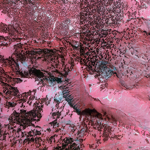
CIR-Luftbilder 1994 Vorarlberg Teilbereich Egg-Sibratsgfäll-Bezau
CIR-Orthofotomosaik Befliegung Vorarlberg 1994 Teilbereich Egg-Sibratsgfäll-Bezau
(3 Kanal CIR-Raster-ECW (NIR-R-G))
Datenquelle:
ir1994_25cm.ecw
Simple
- Date (Creation)
- 2009-11-27
- Date (Revision)
- 2024-04-12T12:00:00
- Code
- 212dd2a8-04dc-420f-ba65-488c0ee8e4cc
- Point of contact
-
Organisation name Individual name Electronic mail address Role Vorarlberg, Landesamt für Vermessung und Geoinformation, Abteilung Geoinformation
Point of contact Vorarlberg, Landesamt für Vermessung und Geoinformation, Abteilung Geoinformation
Custodian Vorarlberg, Landesamt für Vermessung und Geoinformation, Abteilung Geoinformation
Publisher Vorarlberg, Landesamt für Vermessung und Geoinformation, Abteilung Geoinformation
Owner
- Maintenance and update frequency
- Not planned
-
VOGIS Thema 1.0.0
-
-
luftbilder
-
-
VOGIS Unterthema 1.0.0
-
-
orthofotos
-
-
GEMET - INSPIRE themes, version 1.0
-
-
Orthofotografie
-
-
GEMET
-
-
Luftbildfotographie
-
Luftbild
-
- Keywords
-
-
infrarot
-
egg
-
sibratsgfäll
-
bezau
-
- Access constraints
- Copyright
- Use constraints
- otherRestictions
Resource constraints
- Spatial representation type
- Grid
- Distance
- 25 cm
- Language
-
ger
- Character set
- UTF8
- Topic category
-
- Planning cadastre
))
- Reference system identifier
- EPSG / MGI / Austria GK West (EPSG:31254) / 8.6
- Number of dimensions
- 3
- Cell geometry
- Point
- Distribution format
-
Name Version ECW
-
Digital transfer options
- OnLine resource
-
Protocol Linkage Name OGC:WMS-http-get-capabilities
https://vogis.cnv.at/mapserver/mapserv?map=i_luftbild_1994_egg_sibratsgfaell_bezau_ir_wms.map&service=wms&request=Getcapabilities&VERSION=1.3.0 ir1994_25cm
- Hierarchy level
- Dataset
Extent
- Statement
-
Eigene Erfassung / Bundesamt für Eich- unf Vermessungswesen (BEV)
Metadata
- File identifier
- 212dd2a8-04dc-420f-ba65-488c0ee8e4cc XML
- Metadata language
- Deutsch
- Character set
- UTF8
- Hierarchy level
- Dataset
- Date stamp
- 2025-09-30T19:14:40.534Z
- Metadata standard name
-
ISO 19115:2003/19139
- Metadata standard version
-
1.0
- Metadata author
-
Organisation name Individual name Electronic mail address Role Vorarlberg, Landesamt für Vermessung und Geoinformation, Abteilung Geoinformation
Point of contact
Overviews
Spatial extent
Provided by
