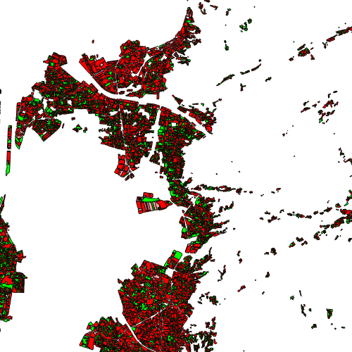
Bauflächennutzung Vorarlberg 2022
Die Bauflächennutzung (2022) Vorarlbergs stellt den tatsächlich bebauten Teil eines Grundstücks dar, welches als Baufläche (BK, BW, BM, BB) gewidmet wurde. Dieser Teil ergibt sich aus der Differenz von Grundstücksfläche minus ungenutzter Fläche und wurde anhand des Orthofotos (2022) per Hand herausgearbeitet. Dabei wird zwischen genutzt, schlecht genutzt (z.B. Parkplatz) und ungenutzt unterschieden.
Wichtige Felder und Datentypen der Attributtabelle:
AREA (double) Fläche des Polygons/der Parzelle
BELEGUNG (string) beschreibt die tatsächliche Nutzung
FW (string) Flächenwidmung - Signatur
FW (string) Flächenwidmung - Text
STAND (string) Stand der Daten
Datenquelle: bauflaechennutzung_2022.shp
Simple
- Website
-
Protocol Linkage Name UKST
Tabellenort
UKST
Shapefile-Path
UKST
QGIS-QML-File
UKST
QGIS-Project-File
- Date (Creation)
- 2025-03-01
- Date (Revision)
- 2025-03-06T08:20:03
- Citation identifier
- AT.0025.31.00 / fc2f3121-7740-435d-b3b3-c52e8c0f2579
- Presentation form
- Digital map
- Point of contact
-
Organisation name Individual name Electronic mail address Role Vorarlberg, Amt d. LReg., Abteilung VIIa - Raumplanung
Stefan Kaps
Point of contact Vorarlberg, Amt d. LReg., Abteilung VIIa - Raumplanung
Stefan Kaps
Custodian Vorarlberg, Landesamt für Vermessung und Geoinformation, Abteilung Geoinformation
Publisher Vorarlberg, Amt d. LReg., Abteilung VIIa - Raumplanung
Stefan Kaps
Owner
-
VOGIS Thema 1.0.0
-
-
raumplanung
-
-
VOGIS Unterthema 1.0.0
-
-
bauflaeche
-
- Keywords
-
-
bebaute fläche
-
bauland
-
bodennutzung
-
- Access constraints
- Copyright
- Other constraints
-
no limitations
- Denominator
- 5000
- Language
- Deutsch
- Topic category
-
- Planning cadastre
))
- Reference system identifier
- EPSG / MGI / Austria GK West (EPSG:31254) / 7.9
- Distribution format
-
Name Version ESRI Shapefile
1.0
- OnLine resource
-
Protocol Linkage Name WWW:LINK-1.0-http--link
https://vorarlberg.at/-/raumplanung-und-baurecht Informationen
OGC:WMS-http-get-capabilities
https://vogis.cnv.at/geoserver/vogis/bauflaechennutzung_2022/wms?service=wms&request=Getcapabilities bauflaechennutzung_2022
OGC:WFS-http-get-capabilities
https://vogis.cnv.at/geoserver/vogis/bauflaechennutzung_2022/wfs?service=wfs&request=Getcapabilities Geoserver-WFS
WWW:DOWNLOAD-1.0-http--download
https://vogis.cnv.at/geoserver/vogis/bauflaechennutzung_2022/ows?service=WFS&version=1.0.0&request=GetFeature&typeName=bauflaechennutzung_2022&maxFeatures=100000&outputFormat=SHAPE-ZIP Shapefile-Download
WWW:DOWNLOAD-1.0-http--download
https://vogis.cnv.at/geoserver/vogis/bauflaechennutzung_2022/ows?service=WFS&version=1.0.0&request=GetFeature&typeName=bauflaechennutzung_2022&maxFeatures=100000&outputFormat=gpkg Geopackage-Download
- Hierarchy level
- Dataset
- Statement
-
Digitalisierung auf Basis Luftbild und Grenzen des digitalen Katasters
Metadata
- File identifier
- fc2f3121-7740-435d-b3b3-c52e8c0f2579 XML
- Metadata language
- Deutsch
- Hierarchy level
- Dataset
- Date stamp
- 2025-07-01T11:26:33.037Z
- Metadata standard name
-
ISO19115
- Metadata standard version
-
2003/Cor.1:2006
- Metadata author
-
Organisation name Individual name Electronic mail address Role Vorarlberg, Landesamt für Vermessung und Geoinformation, Abteilung Geoinformation
Point of contact
Overviews
Spatial extent
Provided by
